Case Study: Drone Fly Permission Platform – A Complete UAV Solution
15+ Years of Experience
800+ Projects Completed
Flexible Engagement Models
100% client Satisfaction
The advancement of drone technology has led to a significant increase in the number of UAVs operating in various airspaces. This growth presents several challenges in managing airspace efficiently, safely, and in compliance with diverse regulatory frameworks. The ALL ONE in the SkyShare initiative aimed to tackle these pressing issues by developing a comprehensive UAV flight permission platform.
Each country has its own set of aviation rules and regulations. UAV operators must navigate through this complex web of rules, which can vary significantly between regions and are often subject to frequent updates.
Ensuring that UAV operations adhere to these diverse regulations is a daunting task, especially for operators who manage fleets across multiple countries.
With the increasing number of UAVs sharing the airspace with manned aircraft, there is a heightened risk of collisions. Ensuring that UAVs operate in safe zones and avoid restricted areas is crucial.
Continuous monitoring of UAVs to ensure they remain within authorized airspaces and respond to dynamic changes, such as emergency no-fly zones.
Traditional methods of obtaining flight permissions are often slow and cumbersome, leading to operational delays and increased costs.
Efficiently managing multiple UAVs, pilots, and flight plans to maximize productivity and minimize downtime.
Integrating up-to-date and precise national airspace data into a single platform is challenging. Inaccurate or outdated information can lead to regulatory breaches and safety risks.
Airspace conditions and regulations can change rapidly. Ensuring that the platform reflects these changes in real-time is essential for compliance and safety.
Designing a platform that is easy to use for both novice and experienced UAV operators. The interface must be intuitive, providing quick access to essential features without a steep learning curve.
The platform must handle a growing number of users and UAVs without compromising on performance or user experience.
The platform needed to accommodate a wide array of regulations from different countries and regions, ensuring that UAV operations are compliant everywhere.
Implementing robust safety measures to prevent collisions and manage UAV movements within authorized airspaces, requiring real-time data processing and monitoring.
Reducing the time and effort required to obtain flight permissions, thereby enhancing the overall efficiency of UAV operations.
Incorporating precise and up-to-date national airspace data into the platform and ensuring that it dynamically updates in response to changes.
Creating an intuitive and scalable user interface that caters to the needs of various users, from hobbyists to professional UAV operators.
The development of the UAV Flight Permission platform required a multidisciplinary approach, combining expertise in aviation regulation, software development, and user experience design. The team consisted of:
To provide insights into regulatory requirements and safety standards.
To build a robust and scalable platform.
To create an intuitive interface for various user types.
To ensure accurate integration of airspace data and analytics for operational insights.
To address these challenges, we have introduced a comprehensive software solution tailored for UAV operators and regulators.
Key features and functionalities include:
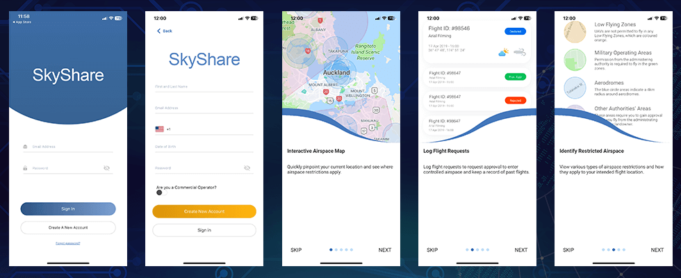
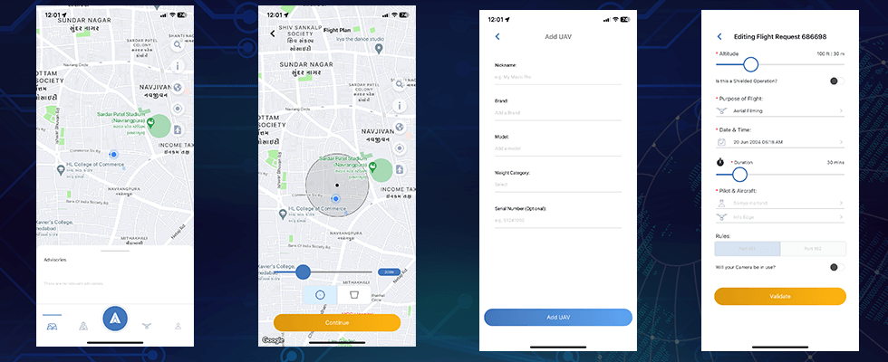
A user-friendly interface allowing customers to manage their drones, pilots, and flight operations efficiently.
Secure user authentication through mobile apps or web browsers to access the platform’s features.
Enter detailed information about each UAV, including model, capabilities, and registration details.
Input and manage credentials and qualifications of remote pilots to ensure compliance with regulatory standards.
Operators can view regulatory zones (e.g., No Fly Zones, Restricted Areas, and Sensitive Areas) on a map for better planning and compliance.
Submit requests for flight permissions in controlled airspace, including necessary details and intended flight paths.
Expedite approval processes for flight requests, reducing downtime and enhancing operational efficiency.
Integrate national airspace data into the platform to ensure accurate and compliant UAV operations.
Define operational rules and guidelines for UAV flights to ensure safety and compliance.
Clarify responsibilities and liabilities within the ‘U-Space’ airspace in a FIR where ANSPs (Air Navigation Service Providers) have full responsibility.
Administrators can establish and manage No Fly Zones, Restricted Areas, and other sensitive zones within the airspace.
Areas where UAV operations are strictly prohibited unless special authorization is obtained.
Regions where flights require specific permissions from relevant authorities.
Zones where heightened caution is advised due to potential risks, though flights are generally allowed.
Areas where operators must be vigilant, typically due to temporary restrictions or advisory warnings.
Absolute prohibition of UAV operations due to safety, security, or environmental concerns.
Locations where UAVs must disable certain sensors (e.g., cameras) to protect privacy or sensitive activities.
Prisons, embassies, and military installations where UAV operations are heavily restricted or banned.
Strict regulations and procedures for UAV operations near airports to prevent interference with manned aircraft.
The implementation of the ALL ONE in the SkyShare platform yielded significant benefits:
Improved compliance with aviation safety standards, reducing the risk of UAV-related incidents.
Streamlined processes for obtaining flight permissions, leading to reduced operational downtime.
Simplified navigation through complex regulatory landscapes, ensuring adherence to local and international regulations.
Positive feedback from UAV operators due to the intuitive and user-friendly interface.
Successful integration of national airspace data, providing reliable information for UAV operations.
Understand what drives customer satisfaction and loyalty through their genuine feedback and insights.

We've worked with Amar Infotech since 2014 on Lyrics Guru. Their expertise in Flutter Mobile App Development and Laravel admin panel was exceptional. Their support and dedication make them a highly recommended tech partner.

Amar Infotech provided excellent service in developing our Tour Package Extranet. Their Laravel expertise made tour package management seamless. Their professionalism and dedication were outstanding. Highly recommended!

Thanks to their expertise, we now have a fully functional Flight Booking website tailored to our needs. Their dedication and technical proficiency were invaluable. I highly recommend Amar Infotech for their excellent service.

Amar Infotech revolutionized Sammy Tours Sri Lanka with their Travel Technology Solutions. Their expertise and dedication enhanced our website, streamlined operations, and boosted business growth. Highly recommend their services!

Amar Infotech, including Hitesh, Satya, and Somya, did an excellent job on our laundry multi-vendor marketplace app. Their Laravel expertise and insightful suggestions helped create a seamless, user-friendly, and efficient mobile app.

Amar Infotech delivered exceptional support for our hyperlocal grocery app development. Their expertise, clear communication, and dedication helped us build a seamless, scalable platform. I highly recommend their services!

Select the ideal remote team tailored to your business needs.

Enjoy up to 30% savings with our competitive solutions.

Leverage the expertise of over 100 skilled IT professionals.

Ensure success with agile project management and consistent, reliable outcomes.

Benefit from cutting-edge technology and creative approaches that drive your business forward.
Discover how we drive success with innovative solutions tailored for your needs. Get a comprehensive overview of our expertise and achievements in just one click.
Download Now
Celebrating our journey of excellence with accolades that inspire us to reach new heights.


From Concept to Code – See How Amar Infotech Delivers Excellence.
Proven Success Across Web, Mobile, AI, and Cloud Solutions.
Explore our deep industry knowledge and forward-thinking perspectives
Expanding horizons with a global network of representatives dedicated to delivering excellence across borders.

4th Floor, Sunrise Avenue, Stadium - Commerce Six Road, Ahmedabad, INDIA
sales@amarinfotech.com
Al Jones (IT Consultant and Project Manager), Phoenix, AZ 85013
Contact@AlphaVendingService.com
Ronak Patel (Sales Person), 64 caranci crescent Brampton ON Canada
ronak@amarinfotech.com
Jessica (Sales Person), 9 nirimba drive quackers hill nsw 2763
jessica@amarinfotech.com
Adam (Sales Person) in Breda, Netherlands
adam@amarinfotech.comAmar InfoTech is a top web design and development organization focused on delivering high-quality solutions that drive digital growth. We create high-performance websites, apps, and products for exceptional client experiences.
Our innovative approach empowers businesses to maximize ROI and thrive in a competitive market, providing tailored solutions that enhance online presence and success.


Looking for digital excellence?
Book a ConsultationCopyright © 2009 - Amar Infotech - All rights reserved